


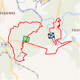
Ardèche-160930 - Païolive-Casteljau

randodan
Gebruiker

Lengte
14,2 km

Max. hoogte
251 m

Positief hoogteverschil
288 m
Km-Effort
18,2 km

Min. hoogte
113 m

Negatief hoogteverschil
360 m
Boucle
Neen
Datum van aanmaak :
2017-01-01 00:00:00.0
Laatste wijziging :
2017-01-01 00:00:00.0
5h00
Moeilijkheid : Gemakkelijk

Gratisgps-wandelapplicatie
 SityTrail
IGN / Geografische instituten
SityTrail Plus
De wereld gaat voor u open
Over ons
Tocht Stappen van 14,2 km beschikbaar op Auvergne-Rhône-Alpes, Ardèche, Les Vans. Deze tocht wordt voorgesteld door randodan.
Beschrijving
En Cours
Foto's


Plaatsbepaling
Land:
France
Regio :
Auvergne-Rhône-Alpes
Departement/Provincie :
Ardèche
Gemeente :
Les Vans
Locatie:
Chassagnes
Vertrek:(Dec)
Vertrek:(UTM)
593802 ; 4916367 (31T) N.
Opmerkingen